The state’s latest water use numbers have been published by the Utah Division of Water Resources and can be found on the recently overhauled and upgraded Open Water Data website.
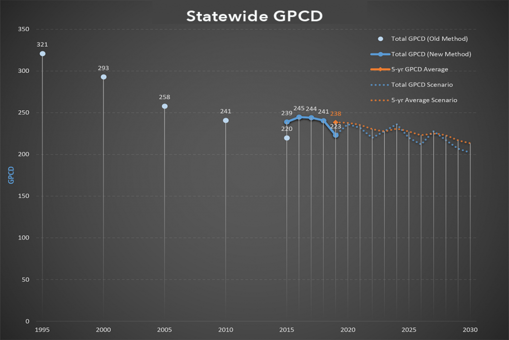
The latest municipal and industrial (M&I) numbers are from 2019 and show that statewide per capita water use for potable and secondary water is 223 gallons per capita per day (GPCD). In 2018, the total GPCD was 241 (2017 – 244 and 2016 – 245). M&I includes residential, commercial, institutional (for example, schools and parks), and industrial water use.
“2019 was a great water year with beneficial weather patterns,” said Rachel Shilton, the division’s river basin planning manager. “Water use can vary dramatically because of weather. In contrast, 2020 has been hot and dry, which usually results in higher usage.”
The data from 2015 is the state’s baseline for planning and tracking water conservation achievements. Data is collected annually, allowing for five-years of consecutive data to better monitor trends and adjust for weather fluctuations. “The five-year average provides a more accurate picture of water use,” said Shilton. (See graph)
Utah has one of the most comprehensive water reporting practices in the nation because it includes all potable, secondary and reuse by all users (residential, commercial, institutional and industrial) in its GPCD. This all-inclusive method is important for planning purposes but means that Utah’s water use numbers look higher than other cities or states that don’t include all water use in their calculations.
“There isn’t a national standard for reporting water use, which makes meaningful comparisons difficult,” said Shilton. “Other states don’t collect the same information that we do, but if you look at just metered residential use for Salt Lake City – the water use number reported by some municipalities – the GPCD is 96.”
Water use data collection has improved over the years and is a detailed process involving the Division of Water Resources, the Division of Water Rights and the Division of Drinking Water. The process typically takes about a year, which is why the numbers lag. (See How the Data is Collected below.)
Open Water Data Website
In addition to housing water use data, the division’s Open Water Data website includes many new datasets, maps, apps and dashboards. The site provides access to water data produced and maintained by the division that is useful for planning purposes.
“This interactive site allows users to answer many fundamental questions related to Utah’s water supply and use,” said GIS Manager Aaron Austin. “Access to accurate data is at the core of good decision making. The upgrades make the site more intuitive and in many cases make it possible to interact with and understand the data without having to download anything.”
The website features three primary data categories: Municipal and Industrial Water Use, Water-Related Land Use and Water Budget. A wide variety of data can be explored and downloaded in many formats. Many are summarized by state, county, basin or water supplier boundaries. A gallery of online maps as well as resources from outside entities are also available.
For more information, contact Kim Wells, public information officer, at 801.803.0336 or email kimwells@utah.gov.
How the Data is Collected
- The Division of Water Resources gets a list of active public water systems from the Division of Drinking Water.
- The Division of Water Rights works with these water systems throughout the year, helping them report accurate source and use data and helps water systems adjust billing inputs so water use is tracked in the right categories. Updated boundaries are provided to the Division of Water Resources and the GIS layer is updated.
- By December, Water Resources supplies Water Rights with the estimated population for each system. This population is pre-populated on the annual water use form.
- In January, Water Rights sends out the annual water use form to each public water provider.
- The forms are due back to Water Rights by March 15.
- Water Resources reviews the submitted data and flags possible errors.
- Water Rights contacts systems with flagged data and corrects any potential errors.
- Potable data is typically finalized by September.
- Water Resources compiles metered secondary water, then estimates unmetered secondary water, and both are added to the database.
- The data set is given to the Water Resources Technical Services Section to format for the Open Water Data website.
- The data set is posted on the Open Water Data website.


